


stevenson1

ARVIEU
User
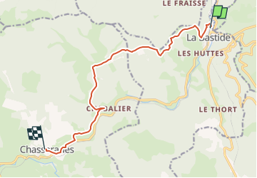

Length
12 km

Max alt
1313 m

Uphill gradient
401 m
Km-Effort
16.8 km

Min alt
1022 m

Downhill gradient
249 m
Boucle
No
Creation date :
2024-02-12 17:42:10.767
Updated on :
2024-02-12 17:43:18.605
4h00
Difficulty : Easy

FREE GPS app for hiking
 SityTrail
IGN / Geographical institutes
SityTrail Plus
The world is yours!
About
Trail Walking of 12 km to be discovered at Occitania, Lozère, La Bastide-Puylaurent. This trail is proposed by ARVIEU.
Positioning
Country:
France
Region :
Occitania
Department/Province :
Lozère
Municipality :
La Bastide-Puylaurent
Location:
Unknown
Start:(Dec)
Start:(UTM)
571759 ; 4938191 (31T) N.
Comments